Ballymeanoch, Argyll
Stones
of Wonder
QUICK LINKS ...
HOME PAGE
INTRODUCTION
WATCHING
THE SUN, MOON AND STARS
THE
MONUMENTS
THE
PEOPLE AND THE SKY
BACKGROUND
ARCHAEOASTRONOMY
USING
THE SITE DESCRIPTION PAGES
VISITING
THE SITES
THE
LEY LINE MYSTERY
THE
SITES
ARGYLL
AND ARRAN
MID
AND SOUTH SCOTLAND
NORTH
AND NORTH-EAST SCOTLAND
WESTERN
ISLES AND MULL
Data
DATES
OF EQUINOXES AND SOLSTICES, 1997 to 2030 AD
DATES
OF MIDSUMMER AND MIDWINTER FULL MOONS, 1997 to 2030 AD
POSTSCRIPT
Individual
Site References
Bibliography
Links
to other relevant pages
Contact
me at : rpollock456@gmail.com
Standing Stone Alignments NR833964*
How to find : The stones are situated 2.5km south of the village of Kilmartin on the A816. Leave your car in the car park for visitors to the Duncraigaig chambered cairn, which is signposted on the main road. Walk a short distance from the car park back along the road, and cross a stone stile into the field.
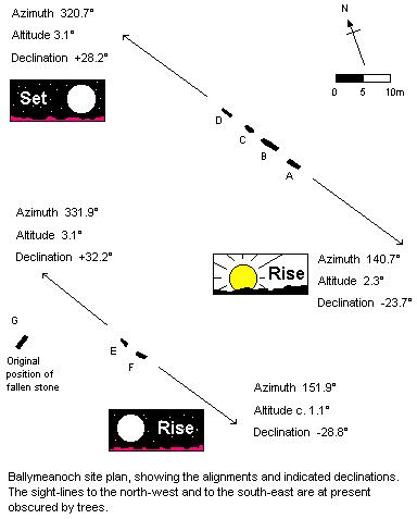
Best time of year to visit : Plantations now block the views, but the trees will one day be removed ; it is worth checking the site on the way to visit Nether Largie or any of the other mid Argyll sites featured in this Web guide. When clear, the indicated lines are to both the northerly setting moon and the southerly rising moon at the major standstill, and to the rising sun at midwinter.

The two alignments at Ballymeanoch are the most visible part of a concentration of ancient monuments in the immediate area.
Beside the road in the trees lies the Duncraigaig Bronze Age cairn, which was originally more than 30m in diameter. In the south side of the cairn is a cist with a huge capstone. Burials and cremation evidence were found in the cist when it was excavated. The cairn is in state care, as are the Baluachraig cup-and-ring markings, within a metal fence just to the north of the cairn. (Enter field by a gate from the main road). More cupmarkings lie in rough woodland by the abandoned settlement just east of the main road.
Thirty metres to the north-east of the four stone alignment is a kerb cairn, and 130m to the south-west lies a henge monument.
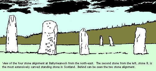
However, our main interest lies with the standing stones. There are six stones standing today, two in one alignment and four in the other. The alignments are approximately parallel, and the orientation is north-west to south-east. The long axes of the flat-faced sandstone slabs are parallel to the alignment, so there is no doubt which orientations were being emphasised.

The four stone alignment, which is closest to the road, is much more impressive close up than at a distance, as the height of the stones can be better appreciated. This is often true of megalithic sites described in this guide. The tallest stone is 4.1m high. To the north-west the alignment indicates the most northerly setting point of the midwinter full moon at the major standstill. To the south-east the stones indicate the rising point of the sun at the winter solstice.
On the east face of stone B (see plan) are about 70 cupmarks, 13 of which have rings around them, and some with gutters. The west face of stone C has forty cupmarks and two cups and rings. Stone A has one cup mark on the east face.
The two stone alignment indicates to the southeast the most southerly rising point of the moon at the major standstill. To the north-west an indicated declination of about 32º has no known significance.
Formerly a seventh stone (G) with a hole through it, and several cupmarks, stood 18m west of this pair. It fell in the 19th century, and the stump of the stone was excavated in 1977 by John Barber1. The axis of the stump lay NW-SE, like the alignments. Three small deposits of cremated bone were found in the socket. The remains of this stone have been placed out of the way of farm machinery in the drain beside the kerb cairn at the edge of the field.
This site is, like the nearby Nether Largie setting, one of the most important and impressive ancient sites in Scotland, which is set in an area which had some profound significance for the Neolithic and Bronze age populations of Scotland.
The Ballymeanoch alignments; there are often cattle in the field.